The only difference between adventure and disaster is preparedness.

Tuesday, December 22, 2015

Storm Update from KLOG

Wind Wham

Posted on 22nd December 2015 at 09:38
Work continues on dozens of power outages and road blockages that were caused by yesterday’s windstorm in the local area, an event that downed trees all over Cowlitz County. PUD line crews and road crews have been on the move since about 1:30 yesterday afternoon, when the winds first hit. Large swaths of the county are still without power, and PUD officials say that it still may be several hours before repairs are complete. The latest numbers show that about 15,000 PUD customers got knocked out yesterday, and that number was cut to about 2,000 by this morning. Some of the damage resembled the 1962 Columbus Day storm, with trees falling onto houses and cars in multiple locations around the region. At this point, there are no reports of injury connected to this damage. The Cowlitz PUD says work is continuing as quickly and as safely as possible, to try and get power restored to everyone. City and county road crews are also working as quickly as possible to clear trees and limbs from the streets. Be aware and be patient as these crews work to restore electricity and road access.

The peak wind gust recorded in this area was 46 miles an hour, recorded at 2:15 pm at the Southwest Washington Regional Airport in Kelso. There was also a 46 mile-an-hour gust in Lexington, 34 miles an hour in Longview, 31 miles an hour in Kalama, 23 miles an hour in Castle Rock, 29 miles an hour at the station next to the Lewis and Clark Bridge, and 64 miles an hour up on Abernathy Mountain.
Longview was particularly hard-hit, with a number of large trees coming down; if a city-owned tree has come down onto your home or vehicle, you’re advised to call 442-5803 to file a report and to get on the list for removal. Trees in the planting strips along city streets are owned by Longview, and city crews will be responsible for their removal. Again, call 442-5803 if a City of Longview-owned tree came down onto your home or your vehicle.

There’s actually a name for yesterday’s weather event, which the Weather Service describes as “straight-line winds.” They say that these straight-line winds are generated by thunderstorms, but they aren’t associated with rotation, like a tornado. They’re associated with the “outflow and downdraft” components of a thunderstorm. NWS officials say that these winds can cause the same kind of damage as a tornado, but all of that damage falls in the same general direction. These winds are also called “Derechos,” and can be much more devastating than yesterday’s event.
Monday, December 21, 2015

What Are Straight Line Winds?

Wondering what on Earth that wind storm was all about today?  According to the National Weather Service, what we experienced is called "straight line winds."  To learn more about this weather phenomenon click here: http://www.crh.noaa.gov/Image/dvn/downloads/quickfacts_Straightline_Wind_Derecho.pdf

Recognizing Frostbite


Recognizing Frostbite


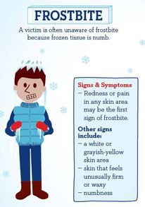
CDC FrostbiteThe official start of winter begins December 21, but some parts of the country are already experiencing severe winter weather. According to the Centers for Disease Control and Prevention (CDC), serious health problems can result from prolonged exposure to the cold. One of the most common problems is frostbite.
 
Frostbite is an injury to the body caused by freezing, and most often affects the nose, ears, cheeks, chin, fingers, or toes. Signs of frostbite include: 
 
 
·        White or grayish-yellow skin area;
·        Skin that feels unusually firm or waxy; and
·        Numbness. 
If you detect symptoms of frostbite, seek medical care immediately. If medical care is not available, follow these important tips from the CDC, including: 
·        Get into a warm room as soon as possible;
·        Do not walk on frostbitten feet or toes, unless necessary. Doing so can increase the damage; and
·        Immerse the affected area in warm water. 
For more information about frostbite and how to prevent it, check out this video from the National Weather Service.


Thursday, December 17, 2015

Updated Weather Forecast

The Department of Emergency Management attended another briefing from the National Weather Service today. They didn’t make any changes to the rainfall total, however, they did make a revision to their wind forecast.

The Lower Columbia area can expect gusty conditions beginning around 6:00 p.m. tonight and lasting until 2:00 a.m. Gusts are expected to be anywhere 30-45 mph. This is also when we can expect the period of heaviest rain. The rain will begin to taper off tomorrow.

The Cowlitz River was downgraded from “Flooding Possible” to “River to Monitor.”

Is Your Vehicle Ready for Winter?


Winterize Your Vehicle


Winterize your carYou may have prepared your home for winter weather; now it’s time to prepare your car. Seasonal changes also mean changes to your emergency supply kit.
America’s PrepareAthon! encourages you to update your vehicle’s emergency kit with several items, including:

·        A shovel;
·        Jumper cables;
·        A bag of sand or cat litter; and
·        Warm clothes. 
Avoid many dangerous winter travel problems by planning ahead. Before you hit the road, have a mechanic check items on your vehicle, including:
·        Antifreeze levels – ensure they are sufficient to avoid freezing;
·        Battery and ignition system – terminal should be clean;
·        Brakes – check for wear and fluid level; and
·        Tires – make sure they have adequate tread.
For more ways to prepare your car for winter weather, check out the How to Prepare for a Winter Storm guide from America’s PrepareAthon!

Wednesday, December 16, 2015

Why Does It Take So Long to Reopen a Road?

Great info from the Washington State Department of Transportation:
http://wsdotblog.blogspot.com/2015/12/why-does-it-take-so-long-to-reopen-some.html

Beacon Hill Closure at 100 Block

From Cowlitz County Department of Public Works: Temporary Road Closure at Beacon Hill Road in Longview. The removal of a wood platform from the elevated rail line will require the closure of a portion of 100 block of Beacon Hill Drive, beneath the rail line.

The closure will occur on Saturday, December 19th from 7:00 a.m. to 5:00 p.m. A detour route around the project site will be available and will be clearly signed.

Please use caution near construction zones and obey the directions of traffic control personnel.

Tuesday, December 15, 2015

Commissioner's Office Allows Free Waste Disposal For Those Affected by Flooding


The Board of Cowlitz County Commissioners has agreed to provide vouchers for free disposal of waste, storm debris and demolition/reconstruction material generated as a result of the storm event of December 8th, 2015.

This voucher will be retroactive to the 8th of December.  Residents can fill out a card at the three locations listed below and take the voucher to Waste Control.  For those who disposed of storm-related waste prior to today, you can be reimbursed by providing a receipt from Waste Control and filling out the card provided at any of the three locations listed. 

As per usual requirements, Waste Control will check ID to verify residency.  If you have questions about this program please call the Commissioner’s office at 577-3020.

Cowlitz County Public Works:  1600 13th Avenue, Kelso, WA

Cowlitz County Assessor’s Office: 207 N. 4th Avenue, Kelso, WA, 2nd Floor

Cowlitz County Building and Planning Office:  207 N. 4th Avenue, Kelso, WA 1st Floor

Another Round of Rain


Latest from National Weather Service:  The rain begins late Wednesday night and will continue into Thursday night, with a total of anywhere between 2 and 2 ½ inches in that 48 hour period.  The heaviest rain is predicted to be on Thursday, lasting possibly through Saturday, potentially causing flooding of streets and rivers. 


The heavy rain increases the potential for landslides, downed trees and clogged storm drains.  Expect rises on the Cowlitz River, as well as local streams.  Thursday will also bring breezy conditions, with wind gusts up to 35 mph. 


This is a good time to check your emergency supplies, both in your home and in your car.  It is always a good idea to be ready to be on your own for 72 hours following an emergency.  For a list of preparedness items, check out www.ready.gov.

Sunday, December 13, 2015

Red Cross Flood Clean Up Kits

The Red Cross is handing out flood clean up kits from 10-4 today at the Kelso High School Football Stadium. The easiest way to get there is to go past the Red Lion Hotel, go in through Tam O' Shanter park and access the back side of the stadium. Follow the Red Cross signs. If you have questions, you can call 541-600-6068.

Friday, December 11, 2015

City of Kalama Water

Due to the high turbidity (cloudiness) in the Kalama river, the City has had to shut down the water plant for 2 days and has been using water from the reserviors. Public works is requesting all Kalama residents to conserve water through the weekend. Please avoid pressure washing, large amounts of laundry and any other clean up that may require the use of large amounts of water through the weekend. The water is SAFE to drink. Thank you for your understanding and cooperation

Flood Damage Assessments


If you have sustained flood damage, Cowlitz County Department of Emergency Management is ready to take in damage assessments.  For those with internet access, the form can be found at www.co.cowlitz.wa.us/DEM.  You can fill out the form there and submit it. 

If you do not have access to internet or if you have questions you can call into the call center from 8:00 a.m. to 5:00 p.m. December 11, 12 and 13.  The Call Center can be reached at 577-3177 or 577-3178.

This is the first step in getting a FEMA Federal Disaster Declaration. 

Thursday, December 10, 2015

Update

From KLOG:
The Washington Department of Transportation now says that the I-5 freeway north of Woodland will remain closed until “later” today. Geotechnical engineers have examined the slope, and have determined that it’s safe to start removing some of the debris. There’s still no exact estimate of when northbound traffic might start moving again.
 
After finally re-opening to traffic early this morning, Highway 30 was closed to for several hours in the area of the St. Johns Bridge, due to a major natural gas leak. The westbound lanes re-opened to traffic at about 1:40 pm, but traffic on Highway 30 has been extremely heavy through the day, all because of the I-5 closure. 
 
 If you do plan to use that roadway, budget extra time to deal with this heavy traffic. West Side Highway is down to one lane in the Hazel Dell area, after mud slid onto the road this morning. One lane is open, and traffic is alternating in each direction. The weather and the roads are affecting activities around the area; winter sports events, activities and classes are shut down after classes were closed today in Kelso, Longview, Kalama, Clatskanie and Vernonia. 
 
Woodland and Kalama have already made the call for tomorrow, announcing that there will be no school tomorrow. The Holiday Concert for Seniors at the Longview Library is being postponed for one week. The I-5 closure is also affecting the distribution of The Nickel weekly shopper, as those papers are printed in Oregon. The company is directing people to their web page.
 
Clark County Regional Emergency Services reports that a strong storm cell came through the Battle Ground area late this morning, and there are multiple reports that a tornado touched down. They say that two commercial buildings were damaged, along with several homes. The Weather Service is joining in the damage assessment, and will and later if this actually was a tornado.

Wednesday, December 9, 2015

Road Closures

Kelso:  Olsen Road at the 300 block, Kool Road, Ostrander Road, Washburn Road, Weststock Road, Lomor, Nevada Drive, North Pacific past Ostrander, 400 block of Spencer Creek

Kalama:  Kalama River Road, Green Mountain Rd is ONLY open to residents, Modrow Road at Bates, East Frontage Road, Dupont

Castle Rock:  Storm Road, Madson

Green Mountain Road is Closed to Through Traffic

Green Mountain Road is NOT a viable option for an I 5 detour.  A deputy is stationed there to check ID and only letting residents through at this time.

Updated Weather Report

From National Weather Service

RAIN:
Tonight-Thursday:  0.5 to 1 inch for the interior lowlands
Friday:  Around 0.5 inches for the interior lowlands
Saturday:  Around 0.5 inches for the interior lowlands

WINDS:
In the higher terrain 30-35 mph with gusts to 50 until Saturday
In the lowlands less gusty

I-5 closed NB at Exit 21

Massive traffic snarls at Exit 21 and Dike Rd NB on I-5.  Green Mountain Rd is NOT a viable option for a detour.

Update from Incident Command


The Kalama River road east of Modrow Road is still closed except for emergency vehicle traffic.   Cowlitz County Public Works has made significant progress in removing the debris off of the road but due to downed powerlines and other risks, it is not safe to open the road to the general public at this time. Cowlitz County Sheriff Deputies will be in the area throughout the night to help handle any emergencies that come up.  The Cowlitz Department of Emergency Services will notify the public as soon as the road is open for general public travel.
 
Cowlitz County Department of Emergency Management will update social media with new information as they are able. Information will be posted on Facebook at www.facebook.com/cowlitzcountydem, Twitter at @CowlitzDEMChat or @CowlitzDEM or on our blog at www.cowlitzcountydem.blogspot.com. 

Latest on Flooding Events


Kelso - The Cowlitz County Board of Commissioners formally declared a flood emergency at 10:20 pm on December 8th, 2015. The Incident Command Post opened at 8 pm. Emergency response teams have been established to provide traffic control and assist residents needing to evacuate. Schools have been cancelled in all areas except Toutle-Lake and Woodland

 
Major flooding has occurred in downtown Kalama and essential city services have been transferred to other locations. City Hall has been moved to the Kalama Community Center, fire district operations are headquartered at the Cloverdale Station, and Kalama Police are working out of the Hall of Justice in Kelso.

 
Kalama River Road has multiple slides, stranding over 800 households along the Kalama River. The County has an engineer and multiple road crews on site working to open the road as soon as possible. Residents are urged to stay home until emergency crews can clear the road.


Tuesday, December 8, 2015

Humane Society

Should you need to evacuate, the Humane Society is open and available to take animals. Call 360-957-2306.

Flood Disaster Declaration

Cowlitz County and each of the cities have declared an emergency. We are in response phase at the moment. If you have flood damages, document everything, we will be requesting that information when we switch to recovery phase in order to obtain a federal disaster declaration. More information will be forthcoming as the situation progresses.

Sandbags Available

We are in for another round of rain today. The Cowlitz County Board of Commissioners have agreed to provide sand and sandbags to residents beginning today at 8:00 a.m. Sand and sandbags are available at 2215 Talley Way in Kelso.

You must bring your own shovel and be able to fill and transport.

Monday, December 7, 2015

Flooding possible today through Wednesday

The National Weather Service has issued a Flood Watch for rivers in Cowlitz County. Heavy rain may cause flooding throughout SW Washington and NW Oregon tonight through midweek.

The Flood Watch will continue through Wednesday afternoon. The next storm will move through today, followed by another Tuesday into Wednesday and an additional storm Wednesday night and Thursday. Three to five inches can be expected in our area.

All of this rain combined with saturated soils will cause significant rises on area rivers through Wednesday afternoon.

A Flood Watch means there is potential for flooding based on current forecasts.

Per our update from the National Weather Service, this is a very active weather event that is just beginning. The creeks/streams will rise first, with the rivers cresting later. Landslide events are possible as well.
To check the river level on the Cowlitz River at Castle Rock, click here: http://www.nwrfc.noaa.gov/ri…/station/flowplot/flowplot.cgi…
To check the river level on the Cowlitz River at Kelso, click here: http://www.nwrfc.noaa.gov/ri…/station/flowplot/flowplot.cgi…

Friday, December 4, 2015

All About Landslides

Warning Signs of an Impending Landslide--from the Washington State Department of Natural Resources www.dnr.wa.gov/geology

Landslides can be categorized as shallow or deep seated.  Shallow landslides are common in Washington, often forming as slumps along roadways or fast moving debris flows down valleys or concave topography. 

Deep seated landslides are often slow moving, but can cover large areas and devastate infrastructure and housing developments.  Shallow landslides typically occur in winter in Western Washington and summer in Eastern Washington, but are possible at any time.

Signs of a Shallow Landslide (generally fast moving)
*  Sudden increase in creek water levels, often with increased sediment in the water
*  Sounds of cracking wood, knocking boulders, or groaning of surrounding group, or unusual sounds like the sound of an oncoming train, especially if the sound increases
*  A hillside that has increasing springs, seeps, or saturated ground, especially if it had been dry
*  Formation of cracks or tilting of trees, especially evergreens, on a hillside

Signs of a Deep Seated Landslide (generally slow moving)
*  Newly developing cracks, mounds, or bulging on streets, sidewalks, or the ground in general
*  Sagging or taut utility lines; leaning telephone poles, fences, or trees
*  Sticking windows or doors; new and/or growing cracks in walls, ceilings, or foundations
*  Broken or leaking underground or surface utilities, such as water, septic, or sewer lines
*  Separation of foundation from sill plates; movement of soil away from foundation
*  Changes in water well levels or cessation of well functioning
*  Increase or changes in spring or seep activity; ground becoming soggy or wet

Thursday, December 3, 2015

High Wind Watch Begins at Noon Today

The National Weather Service has issued a High Wind Watch from noon until this evening for Clark, Cowlitz and Skamania Counties. winds 30-40mph with gusts 50-60mph possible.