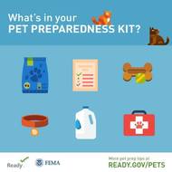
 Every member of
your household should be prepared for disasters. That means pets, too! Every member of
your household should be prepared for disasters. That means pets, too!
Just
as you would create a disaster supply kit for yourself, be sure to also
assemble one for your pet. In addition to having enough food and water to
last at least three days, the Ready Campaign
recommends:
·
Medicines
and medical records: Keep an extra supply of
medicines your pet takes on a regular basis in a waterproof container as well
as records with any instructions;
·
Collar with
ID tag, harness or leash: Your pet
should wear a collar with its rabies tag and identification at all
times. Include a backup leash, collar, and ID tag in your
pet’s emergency supply kit;
·
Crate or
other pet carrier: If you need to evacuate in an
emergency, take your pets and animals with you; and
·
Sanitation: Include pet litter and litter box if appropriate,
newspapers, paper towels, plastic trash bags, and household chlorine bleach
to provide for your pet’s sanitation needs. You can use bleach as a
disinfectant (dilute nine parts water to one part bleach), or in an emergency
you can also use it to purify water.
Note: Please store chlorine bleach safely! Keep products containing
hazardous materials such as chlorine bleach in their original containers and
never remove the labels; never store hazardous products in food containers;
and never mix chlorine bleach with any other household cleaning products.
Mixing may cause chemicals to react, ignite, explode, or release poisonous
gases that will cause very serious breathing problems or death.
For the full list of items you
should include in your pet’s kit, download
Preparing Makes Sense for Pet Owners today!
Keep your pet prepared while on
the go using the American Red Cross Pet First Aid mobile app. Use this app to
help your furry friends during emergencies until you can get to a
veterinarian. It’s available for download on Apple and Android devices.
|
Wednesday, July 6, 2016
Is Your Pet Prepared?


Friday, July 1, 2016
Fireworks Safety
Fireworks
Safety
 Stay safe this holiday. Fire and safety experts agree
the best way to enjoy fireworks is from a distance. Leave the fireworks to the
professionals! Stay safe this holiday. Fire and safety experts agree
the best way to enjoy fireworks is from a distance. Leave the fireworks to the
professionals!
Fireworks are often used to mark
holidays and special events. While these displays may be visually appealing,
they present dangers for consumer use. According to the Consumer Product
Safety Commission (CPSC), hundreds of people are injured each Fourth of July
while using consumer fireworks, including sparklers and firecrackers.
Get the facts about fireworks
safety to share with family and friends. Take a look at this fireworks safety video and visit the CPSC Fireworks Information Center.
|
Tuesday, June 21, 2016
Don't Take to the Trails Without These 10 Essentials
The key to keeping a hike safe and enjoyable is making sure you have the right gear.
- Trail shoes or boots
- GPS, map and compass. A GPS enabled device is handy, but go old-school too. Always carry a map and compass as a backup should your electronic device die or should the unit be unable to pick up a signal
- Extra water and way to purify water should you run out and need to use lake or stream water.
- Rain gear and extra clothing. Try to avoid cotton, which keeps moisture close to your skin.
- Safety items--such as flashlight, whistle and a way to start a fire.
- Extra food
- First aid kit
- Knife or multi-purpose tool
- Sunscreen and sunglasses
- Daypack/Backpack
Tuesday, June 7, 2016
Know Your Role in Wildland Fire Preparedness
You can take steps to improve your safety and potentially reduce damage to your property by taking personal responsibility and action!
READY: Dispose of or relocate combustible material from around your home. Trim trees and bushes to allow ample space between your home and landscape vegetation.
SET: Arrange your "go kit" with prescription medication, emergency supplies, important documents and other essential items. Create your own wildland fire action plan, involve your family and practice exit plans from your home and from your neighborhood.
GO: Get your "go kit" and leave well before the threat approaches. Stay aware of the situation and cooperate with local authorities during evacuation and re-entry processes.
From www.wildlandfirersg.org
READY: Dispose of or relocate combustible material from around your home. Trim trees and bushes to allow ample space between your home and landscape vegetation.
SET: Arrange your "go kit" with prescription medication, emergency supplies, important documents and other essential items. Create your own wildland fire action plan, involve your family and practice exit plans from your home and from your neighborhood.
GO: Get your "go kit" and leave well before the threat approaches. Stay aware of the situation and cooperate with local authorities during evacuation and re-entry processes.
From www.wildlandfirersg.org
Wednesday, June 1, 2016
Register for free boating class
The last free Adventures in Boating certification course until fall, sponsored by the Cowlitz County Sheriff’s Office Marine Division, takes place from 8 a.m. to 3:30 p.m. Saturday, June 4, at the Cowlitz County Search and Rescue Building, 1800 Western Lane, Kelso. Early registration is suggested because classes fill up quickly.
Participants who take the one-day class will be certified to operate a vessel in Washington. Classes are open to anyone who needs to obtain a Washington State Boaters Education Card.
All vessel operators 59 years old and younger must have a Washington Boaters Education Card to operate a vessel in the state. For additional information and resources, visit www.boatered.org.
To register for the class, call Deputy Jordan Spencer at 360-577-3092 or send an email to spencerj@co.cowlitz.wa.us.
Thursday, May 26, 2016
Grilling Safety
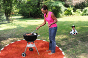 Many people will
be firing up their grills this Memorial Day
weekend and throughout the summer. Many people will
be firing up their grills this Memorial Day
weekend and throughout the summer.
With
grilling season set to be in full force, take time to review a few safety
tips from the U.S. Fire Administration (USFA) to protect
yourself and your guests from a fire or burn injuries:
·
Only use
your grill outside;
·
Keep it
away from siding and deck rails;
·
Keep a
3-foot safe zone around your grill to keep kids and pets safe;
·
Clean your
grill after each use to remove grease, which can start a fire;
·
Place the
coals from your grill in a metal can with a lid once they have cooled;
·
Open your
gas grill before lighting; and
·
Keep an eye
on your grill fire pit or patio torches.
Before
you fire up your grill, check out USFA’s animation on grilling safety.
|
Thursday, May 12, 2016
May is Volcano Preparedness Month in Washington State
VANCOUVER, Washington — May is Volcano
Preparedness Month in Washington, providing residents an opportunity to become
more familiar with volcanic hazards in their communities and learn about steps
they can take to reduce potential impacts. It is a time to commemorate the May
18, 1980 catastrophic eruption of Mount St. Helens, which not only caused
massive destruction and loss of life but also became a catalyst for a new era
of unprecedented scientific discovery, technology development and community
awareness.
The Washington Military Department’s Emergency
Management Division, Washington State Department of Natural Resources, the
Pacific Northwest Seismic Network, the U.S. Geological Survey’s Cascades
Volcano Observatory and a variety of local emergency management agencies
are working together with communities at risk across the state to provide timely warnings and reduce the
negative impacts of future eruptions. Together, the agencies develop and
exercise emergency plans with communities, coordinate communications, conduct
public education programs and plan for short- and long-term recovery in the
event an eruption or lahar should occur.
On Sunday, May 18, 1980, at 8:32 a.m., the bulging
north flank of Mount St. Helens slid away in a massive landslide. Seconds
later, the uncorked volcano exploded and blasted rocks laterally, destroying
centuries of forest growth in a span of several minutes. Nine hours of
explosive volcanic activity ensued, altering the landscape, and what we know
about volcanoes, forever.
Volcano Preparedness Month arrives this year as an
earthquake swarm is underway at Mount St. Helens,
indicating that the volcano remains active. USGS’s seismic data have shown
since 2010 that the quiet Mount St. Helens has a new supply of magma slowly
repressurizing the magma chamber beneath the mountain. As was observed at Mount St. Helens between 1987-2004,
recharge can continue for many years beneath a volcano and an eruption is not
imminent.
New this year is funding for aerial lidar images,
which display ground features in spectacular detail and ease the work of
ground-based geologists. A Colombia-USA binational exchange is in progress
between officials of the two nations responsible for volcano preparedness and
interpretation. Volcano emergency coordination plans are being updated at Mount
Rainier. Agencies are developing new products for public education
presentations, as well as posting signs in communities.
Find information updates about volcanoes and read
about science in action at USGS Volcanoes on Facebook.
Eruptions at Mount St. Helens have demonstrated
the importance of scientists working in close partnership with emergency and
land management agencies to prepare for future eruptions. That includes
installation of comprehensive monitoring networks, developing and practicing
emergency plans, and supporting community education.
Seth Moran, scientist-in-charge at the USGS CVO, notes,
“We’ve seen from other volcanic eruptions that scientists and public officials
must work together in response planning well before a volcanic eruption begins.
We cannot wait around for indications of volcanic reawakening. Our work together
needs to be done now.”
Subscribe to:
Posts (Atom)